The Grenadier Forum
Register Now for enhanced site access.
INEOS Agents, Dealers or Commercial vendors please contact admin@theineosforum.com for a commercial account.

Radio, Satellite, and Adventure Communications

ChasingOurTrunks

Lifetime Supporter
Founding Guard
Local Group Moderator
Local time
1:25 PM
Joined
Sep 25, 2021
Messages
486
Reaction score
1,030
Location
Canada
My car has 11 airbags, I have so far not used any of them. What a stupid waste of money and resources.
Until I need them.
Not so stupid now huh!
Hope for the best but prepare for the worst

Think of how much more payload you could have without all that garbage though, Dave :D

I kid, of course - totally agree with you!
 

ChasingOurTrunks

Lifetime Supporter
Founding Guard
Local Group Moderator
Local time
1:25 PM
Joined
Sep 25, 2021
Messages
486
Reaction score
1,030
Location
Canada
Reading maps is a real pleasure for me, I love it. It's like walking around the area - if you know how to interpret the map.

Although I am an IT guy and electronic maps have many advantages, they can never beat the overview and overall orientation you get with a paper map.

I have to agree, but as a quasi-compromise, I find I get close to that experience with my Ipad Pro; the 12.9 inch screen gives me a decent enough overview. It's not at all the same as the full sheet of paper on the hood of the rig at a rest stop, but it's far better than a phone screen or a typical GPS navigation screen.

Before the digital versions were available, I used to actually scan my map books so I'd have PDF backups, and I often find it fun to do travel planning on the iPad - it's easy to markup and erase or save as necessary. I've not bothered to overlay my position, though I understand some folks use the integrated GPS for that, but I use it as a paper replacement.
 

ChasingOurTrunks

Lifetime Supporter
Founding Guard
Local Group Moderator
Local time
1:25 PM
Joined
Sep 25, 2021
Messages
486
Reaction score
1,030
Location
Canada
My Garmin subscription (for the InReach device) includes access to the Garmin global topographic map database (which you can also access from your phone), which means downloadable maps almost wherever you might find yourself (for the Russian Federation, and I think for Iran, we used OpenStreetMaps.org and Maps.me, which is what the locals mostly use). Only used paper maps in Iran, for the benefit of our local fixer who didn’t trust the sorcery shining out of the device on the dash. Did however carry paper maps as a backup in Central Asia.

Tempted to also note that arguably maps are not so crucial as one might presume, eg. Mongolia - the whole population are ‘overlanders’. Which is a roundabout way of saying that in many places the best way to navigate is to start by asking the locals (could be I learned this from Les on the TV). You may not get a straight geospatial answer but in most parts of the world it triggers the hospitality instinct and can be both the safest and most memorable way to move from place to place - passed along by named contacts, family members etc etc. Cultural exchange.

One benefit of the InReach not discussed is that it has decent battery life if you need to abandon the vehicle and move out on foot. This is not a recommended course of action in remote Australia (the plane will spot a car, but absent a PLB it might not find you on foot in time) but if things have gone south in the Wakhan Corridor or something then it’d be good to be able to grab the thing and scoot.

That has been my experience as well - ask a local for directions, and you're a coin-flip away from an invitation to a birthday party, a community event, a campsite near their home, or a meal with their family in addition to directions wherever you are going.

And great point about the In-Reach - with steady use in tracking mode, it easily lasts a couple of days or more; if we are just using it to send check-in messages (not tracking), where we turn it on for 3 minutes at a time, it'd last months.
 

DaveB

Grenadier Owner
Local time
6:25 AM
Joined
Mar 18, 2022
Messages
6,702
Reaction score
13,608
Location
Toogoom, Fraser Coast Queensland
I have to agree, but as a quasi-compromise, I find I get close to that experience with my Ipad Pro; the 12.9 inch screen gives me a decent enough overview. It's not at all the same as the full sheet of paper on the hood of the rig at a rest stop, but it's far better than a phone screen or a typical GPS navigation screen.

Before the digital versions were available, I used to actually scan my map books so I'd have PDF backups, and I often find it fun to do travel planning on the iPad - it's easy to markup and erase or save as necessary. I've not bothered to overlay my position, though I understand some folks use the integrated GPS for that, but I use it as a paper replacement.
About 1998/99 I was driving a borrowed car in Sydney and my passenger was giving me directions from a street directory (I think it was called a Sydways??)
He said ok in about 300 metres you will turn onto the Pyrmont Bridge.
I hit the brakes and said to him…….the Pyrmont Bridge was closed to vehicles about 20 years ago.
How old is that map?
 

Krabby

Global Grenadier 0076
Forum Moderator
Grenadier Owner
Lifetime Supporter
Local time
4:25 PM
Joined
Nov 5, 2022
Messages
4,591
Reaction score
8,955
Location
New Jersey, USA
dukes of hazzard show GIF

Bridge? I don’t need no stinkin’ bridge.
 

emax

Photo Contest Winner
Grenadier Owner
Lifetime Supporter
Local Group Moderator
Local time
10:25 PM
Joined
Feb 23, 2022
Messages
5,391
Reaction score
8,761
Location
Germany
My wife would have decided better not to try it and would have braked 20 meters before the abyss.

She always stays on the safe side.
 
Last edited:

Logsplitter

Grenadier Owner
Lifetime Supporter
Local time
9:25 PM
Joined
Oct 31, 2022
Messages
2,303
Reaction score
8,502
Location
🇬🇧
Yeah, I love a paper map and always carry them, just not necessarily to a topographic resolution.

When roaming globally it can be very helpful to have a digital record of your journey available as an evidence point for a border control office or security personnel that might be anxious about the nature of your journey/interest and intention in their country etc etc.

As these records reside in the cloud not on the device it also protects one (to an extent) against allegations that one has been somewhere verboten.

And of course one’s digital breadcrumbs are a source of comfort and interest for those following your long range journey.

But yeah, I’m still at heart a Boy Scout trying to spot the mapped geographic feature in the landscape.
My particular joy is pairing a digital theodolite with a paper map.

View attachment 7795656
just looked that up on the iPhone. What a great app👍
 

Logsplitter

Grenadier Owner
Lifetime Supporter
Local time
9:25 PM
Joined
Oct 31, 2022
Messages
2,303
Reaction score
8,502
Location
🇬🇧
We use a Garmin in-reach linked to the iPhone. Which is great for sending texts to family and friends
for mapping we use Maps.Me which we really like also Tracks4Africa which is a brilliant resource especially in southern and east africa.
On a separate note I see the new iPhone 14 has emergency sos via satellite connectivity. This technology is advancing fast so may be available on more phone models in the future
How does the pathfinder app that comes with the Grenadier work ?
 

globalgregors

Photo Contest Winner
Grenadier Owner
Lifetime Supporter
Local time
6:25 AM
Joined
May 15, 2022
Messages
1,342
Reaction score
3,343
Location
Sydney, Australia
We use a Garmin in-reach linked to the iPhone. Which is great for sending texts to family and friends
for mapping we use Maps.Me which we really like also Tracks4Africa which is a brilliant resource especially in southern and east africa.
On a separate note I see the new iPhone 14 has emergency sos via satellite connectivity. This technology is advancing fast so may be available on more phone models in the future
How does the pathfinder app that comes with the Grenadier work ?
Was chatting to the Ineos reps about Pathfinder today. It was described as a solution to which one could upload fhe HEMA map library. HEMA being an Australian mapping service, I concluded that maps could be loaded for offline use, which is quite encouraging for remote international use.

Heads up that the iPhone satellite service is rolling out progressively and is some time off the global availability of your InReach/Iridium service.

With the low orbit megaconstellations on the way though I expect it won’t be long before a single device covers all needs.
 

DenisM

Grenadier Owner
Lifetime Supporter
Local time
6:25 AM
Joined
Jan 26, 2022
Messages
1,959
Reaction score
4,020
Location
Brisbane, Queensland Australia
I have had a good look at the rear of the vehicle there is ample room for a whole chest of Semaphore flags should be good enough for line of sight communications .
I'm pondering a vertical exhaust stack with oil injection operated by an added program to the "toot" button.... simply tap out a smoke signal. ;)
 

Tomdoc

Grenadier Owner
Lifetime Supporter
Local time
9:25 PM
Joined
Oct 24, 2022
Messages
348
Reaction score
1,028
Location
Nottingham
Just to chip in on mobile comms. I have a full UK ham callsign and do a lot of mobile HF and V/UHF work. I will be interested in seeing how fellow IG owners fit radios into the vehicle, mounts, positioning and in particular, antenna mounting for best grounding etc. I will be doing the same here and will share any tips I find. Intrigued to see how easy it will be to tap neatly into the 12V system (auxiliary battery ordered with radios in mind!) Callsign is M0RMY for anyone interested!
 

DaveB

Grenadier Owner
Local time
6:25 AM
Joined
Mar 18, 2022
Messages
6,702
Reaction score
13,608
Location
Toogoom, Fraser Coast Queensland
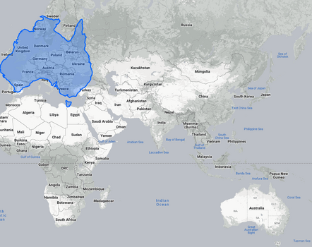
Paper maps are great for local use but when looking at 2D global maps many people don't realise that they are often represented using the Mercator Projection model
This makes everything look smaller or larger than it really is as you get more south/north.

Here is a corrected sizing or proportional size of Australia if it was in the northern hemisphere
Hence the reason we have such wide variety of climates and geography.
Also the reason

1671312635684.png1671312716232.png
1671312918071.png
 

Attachments

  • 1671312585807.png
    1671312585807.png
    434.1 KB · Views: 10

Logsplitter

Grenadier Owner
Lifetime Supporter
Local time
9:25 PM
Joined
Oct 31, 2022
Messages
2,303
Reaction score
8,502
Location
🇬🇧
Paper maps are great for local use but when looking at 2D global maps many people don't realise that they are often represented using the Mercator Projection model
This makes everything look smaller or larger than it really is as you get more south/north.

Here is a corrected sizing or proportional size of Australia if it was in the northern hemisphere
Hence the reason we have such wide variety of climates and geography.
Also the reason

View attachment 7798100View attachment 7798101
View attachment 7798102
I haven’t been yet but it seems big enough do a few months travelling 😎. One a day I hope 🤞🏼
 

globalgregors

Photo Contest Winner
Grenadier Owner
Lifetime Supporter
Local time
6:25 AM
Joined
May 15, 2022
Messages
1,342
Reaction score
3,343
Location
Sydney, Australia
Paper maps are great for local use but when looking at 2D global maps many people don't realise that they are often represented using the Mercator Projection model
This makes everything look smaller or larger than it really is as you get more south/north.

Here is a corrected sizing or proportional size of Australia if it was in the northern hemisphere
Hence the reason we have such wide variety of climates and geography.
Also the reason

View attachment 7798100View attachment 7798101
View attachment 7798102
If there’s one thing one learns doing a circumnavigation it is how perilously small our little ark is…
 

Steveo

Global Grenadier #1009
Grenadier Owner
Lifetime Supporter
Local time
6:25 AM
Joined
Oct 13, 2022
Messages
253
Reaction score
558
Location
Dandenong Ranges, Victoria, Australia
Was chatting to the Ineos reps about Pathfinder today. It was described as a solution to which one could upload fhe HEMA map library. HEMA being an Australian mapping service, I concluded that maps could be loaded for offline use, which is quite encouraging for remote international use.

Heads up that the iPhone satellite service is rolling out progressively and is some time off the global availability of your InReach/Iridium service.

With the low orbit megaconstellations on the way though I expect it won’t be long before a single device covers all needs.
Relating to HEMA Maps, has anyone extensively used either the HEMA app on an iPad or the HX-2 unit? I'm just wondering how good these are?
I have the app on an iPad but have not used it to do detailed route planning or navigation and am just wondering what experiences others have had?

Cheers
 

globalgregors

Photo Contest Winner
Grenadier Owner
Lifetime Supporter
Local time
6:25 AM
Joined
May 15, 2022
Messages
1,342
Reaction score
3,343
Location
Sydney, Australia
Relating to HEMA Maps, has anyone extensively used either the HEMA app on an iPad or the HX-2 unit? I'm just wondering how good these are?
I have the app on an iPad but have not used it to do detailed route planning or navigation and am just wondering what experiences others have had?

Cheers
I've got it loaded on a phone and iPad. I find it somewhat of a PITA for route planning and use it more like a library of paper maps.
Only complication is that while I'm happy to work that way few others seem to be so I usually end up with a HEMA book in the map pocket anyway.
No experience with the HX-2.
 
Local time
6:25 AM
Joined
Jul 1, 2022
Messages
8
Reaction score
19
Location
Gold Coast
Relating to HEMA Maps, has anyone extensively used either the HEMA app on an iPad or the HX-2 unit? I'm just wondering how good these are?
I have the app on an iPad but have not used it to do detailed route planning or navigation and am just wondering what experiences others have had?

Cheers
I have been using the HEMA app on an iPad mounted to the windscreen for off-road navigation with offline maps in Oz since 2015.
I like that 5min vector that’s shown when you’re moving and the fact it keeps the tracks.
 
Back
Top Bottom