The Grenadier Forum
Register Now for enhanced site access.
INEOS Agents, Dealers or Commercial vendors please contact admin@theineosforum.com for a commercial account.

The "Locus Maps" Thread

Mr. Largo WINCH

Grenadier Owner
Lifetime Supporter
Local Group Moderator
Local time
11:18 PM
Joined
Nov 14, 2022
Messages
224
Reaction score
583
Location
Toulon
Pour informations
 

emax

Photo Contest Winner
Grenadier Owner
Lifetime Supporter
Local Group Moderator
Local time
11:18 PM
Joined
Feb 23, 2022
Messages
5,432
Reaction score
8,819
Location
Germany
This thread is not about the Grenadier's pathfinder.

It is about Locus Maps.

...
PS: Sorry @Mr. Largo WINCH, I didn't at first notice your intent. Thank you for the link, it is helpful as it points the right thread. (y)
 
Last edited:

chrsbe

Grenadier Owner
Local time
11:18 PM
Joined
Apr 2, 2023
Messages
255
Reaction score
451
Location
Sternwartestraße, Wien, Österreich
Very interesting!
Gaia supports vector maps and also layered maps. Both can be combined. You can use and also download alternative map tile sources including google earth satellite images in full resolution. I love to combine this with transparent OSM topo vector maps. Is this possible in
Locus? For my next trip I'll do a deep dive into both apps/maps. Last time i did Gaia was the clear winner.
There are also a lot of frustrating things with Gaia.
Downloading maps can be a painful process since you are limited to a certain amount of tiles per download. Being able to download all maps along a track is a nice feature of Gaia. But very often I am not certain about the exact route and decide detail on the go.
Being able to search for POIs outside the own database is a clear plus for Locus. Cellphone coverage assumed.
Also the ability to easily digest several coordinate formats. A big plus for Locus. Not even google can do this and it is not understandable why. This is a fundamental real world feature missing in most apps. I'll test it.
The constant learning journey of navigation....
 

AWo

Local time
11:18 PM
Joined
Feb 28, 2023
Messages
829
Reaction score
1,503
Location
Germany
Habe you noticed tjat some Gaia functions are related to the middle of the screen but there is no cross to mark the middle of the screen?

AWo
I love to combine this with transparent OSM topo vector maps. Is this possible in
Locus
Yes and more. But why? There are ready-to-use hybrid maps, also from Google or Nokia or Bing or Locus.

AWo
 

emax

Photo Contest Winner
Grenadier Owner
Lifetime Supporter
Local Group Moderator
Local time
11:18 PM
Joined
Feb 23, 2022
Messages
5,432
Reaction score
8,819
Location
Germany
Es ist ja, als wenn man einem Ochsen in Horn petzt.

Wenn Du, @chrsbe, unbedingt über Gaja schreiben willst, warum zur Hölle ignorierst Du dann einfach den Titel dieses Threads und machst keinen eigenen mit Deinem Präferenzen auf?

Das ist ignorant ohnegleichen.
 

chrsbe

Grenadier Owner
Local time
11:18 PM
Joined
Apr 2, 2023
Messages
255
Reaction score
451
Location
Sternwartestraße, Wien, Österreich
Hä? Laus über die Leber gelaufen? Ich will was dazu lernen. Bin offen für alles und will niemanden belehren. Wo bin ich denn bitte ignorant ohnegleichen?
 

emax

Photo Contest Winner
Grenadier Owner
Lifetime Supporter
Local Group Moderator
Local time
11:18 PM
Joined
Feb 23, 2022
Messages
5,432
Reaction score
8,819
Location
Germany
Ich hatte mehrfach darum gebeten (siehe z.B. Beiträge #1 und #4), das Thema nicht zu zerfleddern, und ggf. einen eigenen Thread aufzumachen, wenn man Vergleiche mit anderen Systemen machen möchte.

Das steht jedem frei. Aber einen anderen Thread trotzdem für eigene Interessen zu kapern, ist einfach nur daneben.
 
Last edited:

AWo

Local time
11:18 PM
Joined
Feb 28, 2023
Messages
829
Reaction score
1,503
Location
Germany
Maybe I missed out on this. There is a hybrid topo map from google? including contour lines?
No, there is no hybrid-topo-map from Google, but Satellite. However, Loucs supports layering what ever you like and more. There are layering mechanisms available I do not understand anymore. You can keep that simpe,if you like and do complicated stuff (whatever that is used for).

Regarding contour lines, Locus is able to create different kinds of shading. You can 3D-like views when Locus uses height information stored in maps to create shadows or you can use alarming colours to mark different slope angles (good for pointing out avalance areas) and such things.

AWo
 

emax

Photo Contest Winner
Grenadier Owner
Lifetime Supporter
Local Group Moderator
Local time
11:18 PM
Joined
Feb 23, 2022
Messages
5,432
Reaction score
8,819
Location
Germany
I have now taken my first steps with Locus Maps.

The first action was to purchase a one-year Gold subscription. At 24 euros for a year, the price is less than a quarter of some competitors.

Next I installed some vector maps (Germany, Switzerland, Italy) from the LoMaps library and I'm just thrilled. The contour lines, landscape shading and details are excellent. And they're fast: vector maps are stepless at any magnification and don't have zoom levels like rasterized maps. When zooming, the display is therefore absolutely fluid and without any jerking, as occurs with gridded maps when changing from one zoom level to the next. Very, very beautiful, just a joy.

But there are still questions. Maybe I'm too used to traditional navigation systems, but concerning the navigation I am missing
  • the selection of my preference for shortest, fastest, or most economical route
  • the setting to allow or avoid "ferries" or "motorways" or "toll routes"
  • individual vehicle profiles
I guess I just haven't discovered some of it yet. But maybe one or the other doesn't exist at all ...?

I'd appreciate any help.
 
  • Like
Reactions: AWo

emax

Photo Contest Winner
Grenadier Owner
Lifetime Supporter
Local Group Moderator
Local time
11:18 PM
Joined
Feb 23, 2022
Messages
5,432
Reaction score
8,819
Location
Germany
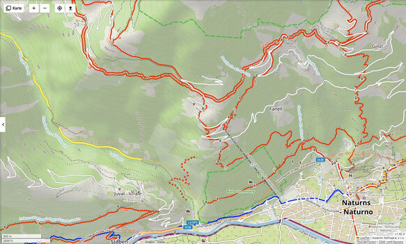
Two screenshots from the PC-based planning app.

This is the area of Schloss Juval, which is the property of Reinhold Messner. The countour lines and the entire rendering are much better and better visible on my tablet and my cellphone. On the lower edge you see the '500 m' scaling, You can zoom down to '30 m' and everything stays sharp and clear, no pixelation effects due to vectorization.

Screenshot_20240405_202916.jpg

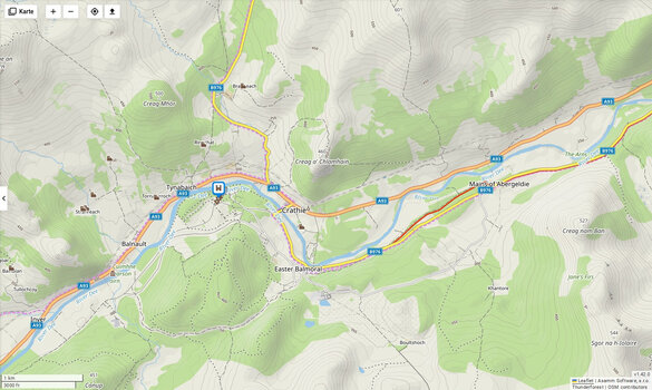
This one shows Balmoral Castle in Scotland at a 1 Km scale. Again, you can go closer up to 30 m.
Screenshot_20240405_202456.jpg

On my tablet both of them look much more contrasty. But you can try yourself with the link below.
Keep in mind that you're using a free web-version. But you get an impression of the maps.

You start in San Francisco at maximum magnification. Just zoom out and watch how nice real-time scaling of vector maps works.

 
Last edited:

Jean Mercier

GG#920
Grenadier Owner
Lifetime Supporter
Local time
11:18 PM
Joined
Sep 10, 2022
Messages
2,434
Reaction score
8,578
Location
Sint-Martens-Latem, Belgium
... With Locus I carry the whole of Europe and a few North African countries always with me (you'll never know! Take the wrong turn in the night and whoops you're in Ksar Ghilane!)...

AWo
Interesting thread @emax., My experience with navigations systems is limited to Google, Waze (it' the same!) and HereWeGo.
My wife gets nervous when I am driving (like yesterday and today) with NO maps, only with compass, therefore it would be better to have a good navigation system.
I have the free version of Locus on my cell phone, and indeed the details are amazing, but when I have no internet connection, I don't have Locus maps of course.

and, @AWo, Ksar Ghilane, have been there :) ! Several times, as I lived some years in the country it belongs to, Very nice place. Even got stuck once when driving back from the "Roman Stones" some kilometers away from the oasis, but got out of it without any help after an hour of struggling with my Pajero. That was long ago, 1995 or so. No navigation system at all!

I am eager to follow this thread and to learn!
 

emax

Photo Contest Winner
Grenadier Owner
Lifetime Supporter
Local Group Moderator
Local time
11:18 PM
Joined
Feb 23, 2022
Messages
5,432
Reaction score
8,819
Location
Germany
but when I have no internet connection, I don't have Locus maps of course
That's one of the advantages of Locus Maps (and of course some other Nav apps): With a Gold subscription (and maybe Silver, I don't know) you can download the maps for offline usage.

There is another Navigation App I use often because it works offline as well, if you want: Map Factor Navigator.


I can highly recommend it. They offer OSM offline maps (worldwide) and TomTom maps as well. OSM is free, TomTom costs money, of course. But for off road use e.g. driving in Sardinia, Corsica, Morocco and the like, Locus Maps seems the better choice.

But I'm still exploring it. 🤷‍♂️
I'd like to have your knowledge about it in this thread. :)

Waze, Here and WeGo a hardcore data thiefs. With respect to privacy they are a nightmare. Be careful.
typo
 
Last edited:

emax

Photo Contest Winner
Grenadier Owner
Lifetime Supporter
Local Group Moderator
Local time
11:18 PM
Joined
Feb 23, 2022
Messages
5,432
Reaction score
8,819
Location
Germany
Quoting myself:
But there are still questions. Maybe I'm too used to traditional navigation systems, but concerning the navigation I am missing
  • the selection of my preference for shortest, fastest, or most economical route
  • the setting to allow or avoid "ferries" or "motorways" or "toll routes"
  • individual vehicle profiles
I guess I just haven't discovered some of it yet. But maybe one or the other doesn't exist at all ...?

I have now looked a little deeper and found the so-called navigation “presets” that you can select for navigation tasks. Preferences combine a number of settings, all of which you can enable for one-click navigation. There are settings like “leave display” but also many others.

I'll have to play around with it before I can say if it's what I'm looking for - but it looks promising. I'll come back to this when I know more.

What I can say so far is that LM has its own idea of intuitiveness ...
 

chrsbe

Grenadier Owner
Local time
11:18 PM
Joined
Apr 2, 2023
Messages
255
Reaction score
451
Location
Sternwartestraße, Wien, Österreich
I teach Gaia GPS and Locus Map, as well as Garmin Tread Overland.....Gaia GPS lacks a lot of functionality compared to Locus Map and also regarding map handling it is far beyond. I only teach Gaia GPS for the Apple world, as Locus is not available on iOS. And for Apple devices Gaia GPS is the best to go. I tested a lot of apps (Gaia GPS, Garmin Overlander, GPS Globe, Locus Map, Orux Maps, Pocket Earth and View Ranger) on the first #5M tour from Slovenia to Albania....and still Locus Map rules!

View attachment 7850907

However, if you're free to choose, I would strongly recommend Locus Map.

If someone is at the Explorer Camp in July on Fehmarn, feel free to ask me...I will give a navigation workshop there....

Of course, feel free to ask here, too...I can help with the three mentioned systems, Gaia, Locus and Garmin Tread Overland. I tested many other apps, as well, but I'm not permanently familiar with them like I'm with these three.

AWo
@AWo, maybe you can convince your friends at locus to give us the Android auto integration. I think there are robust arguments as to why it makes sense. Maybe you have to tell them how useful their app is for People travelling in remote regions in off-road cars. Their focus is obviously on geocaching, hiking and other types of outdoor user groups. The integrated infotainment screen works fine for navigation in our Grenadiers as in other cars with modern comfort and safety features. Why not use it? A setup like your picture could be problematic when airbags blow off—another reason to mainly use the built-in screen. What do you think, do you want to try convincing them?
 
Back
Top Bottom